The selection of Portuguese architect Souto de Moura as this year’s recipient of the world’s highest recognition in the field of architectural design marks a change in direction of the juried selection from an apparent pattern of so-called ‘starchitect’ selections. Over the last few years, the laureates have been internationally recognized designers such as Zaha Hadid, Renzo Piano, Jean Nouvel, Frank Gehry and Peter Zumthor. Souto de Moura is best known for his design of the Paula Rego Museum (photo above) as well as participation in the Serpentine Pavilion of 2005 with Alvaro Siza. AR blogs about why his work was recognized this way.
The Serpentine Pavillion has been the "world stage" for an annual built pavilion design by invited architects, many times in collaboration with world-famous architects, kind of an incubator for international designers run by the British. The Serpentine Gallery, established by the Arts Council of Great Britain, is located in London and constructs a different pavilion each year on the same site by many of the later-crowned Pritzker architects; hence it appears to be the staging area for what is still a closed circle of international designers despite press to the contrary. Serpentine Gallery Projects build dynamic relationships between art, artists and people. Projects and events vary in scale, duration and location, and challenge expectations of where art can be encountered and by whom. These projects invite the public to "encounter" different explorations of architecture and place, such as the work done there by SANAA, the Pritzker Prize laureate from 2010. Peter Zumthor is designing the 2011 pavilion. These projects are like gymnastic exhibitions for designers, since the program is very simply an exhibition space with the designer given a free hand to explore expression and materials. No roof leak challenges for these exercises, but that's not the point.
Interestingly, another arts and architecture gallery, 0III, is on a mission to document places and designs that are not a result of choreographed images in the architectural journals. They support a Blue Plaque Map of London which marks significant locations of important events and structures. They are taking a tangent view of important places that are not restricted to architectural dynamics, but rather meaning of place and its context in history. Yet their contemporary design exhibitions inevitably include these visibly ranked designers once again.
Britain appears to be making a claim to the public realm of design, akin to the Milan International Biennale Trade Fair that is produced throughout Italy every year, except that the Serpentine Pavilion is more purely a design experiment that is gaining prominence on the international stage. The push for design ingenuity and resourcefulness, grounded in the arts, is a welcome change from the marketing and sale of architecture and its branding.
Update: The backstory on the Milan Trade Fair, which was founded in 1961 by Tito Armellini, along with about a dozen other leading furniture manufacturers based near Milan.
The Los Angeles County Department of Public Works is well along on its planning to destroy another pristine urban wilderness to create a new regional sediment dump. The parallels to the destruction of the Arcadia Woodlands is striking. This is yet another pristine wilderness that has been owned by the DPW and fenced off from public access for decades. I was able to circumvent the formidable fence and hiked into this wilderness with a friend to take pictures and see what we could descover up in this beautiful canyon. What we found was a magical place of extreme historic and natural value. We also found that the DPW has already hammered death tags into over sixty mature oak trees including a 400 year old patriarch with an eight foot diameter trunck! The canyon now has survey marker sticks all over. See the photos here.
As Cam points out, the County DPW strategy of encroaching on public lands in order to destroy them is all too familiar. The Arcadia Woodlands was the first example of circumventing the public process, and intimidating the public and the citizens who are trying to raise awareness of these tactics used to remove valuable watershed and riparian areas for the purpose of sediment dumping. All to "preserve" an ill-designed and poorly maintained system for watershed management. This amounts to the removal of valuable ecosystem that is important to the watershed and regional ecosystems and destroy it for short-term financial reasons. It would seem that the County is not qualified to manage this public resource that has immense natural value.
An article from the LA Weekly outlines the issues that have come to a head with the arraignment of "The Arcadia 4" in the Arcadia Woodlands debacle:
“The preeminent threat here is the large population pressures on the edge of development,” Quigley says. “Whether it is to dump, or build roads and housing, government agencies have traditionally undervalued these natural resources, and they routinely draft plans to bulldoze right through them.”
The foursome’s stand lasted just a day, as they sat in the great, gnarly oak trees, defied the bulldozers and 50 Sheriff’s deputies, and made the nightly news.
But the reverberations continue to ripple, calling into question the actions of the county’s Department of Public Works, the alleged complicity of County Supervisor Michael Antonovich in the destruction of the woodland, L.A. County Sheriff Lee Baca’s deputies’ successful attempt to block close-up media coverage and Cooley’s seemingly heavy-handed prosecution of the four activists.
Defense attorney Colleen Flynn, who represents all four protesters, says she is hopeful Cooley’s office would see the folly in playing hardball with the eco-activists.
These actions bode ill for the Hahamongna Watershed Park and La Tuna Canyon, which are now facing the same fate as the Arcadia Woodlands from the County in spite of public protest of these actions.
The global recognition of sustainable energy futures is recognized tonight at 8:30 pm Pacific Daylight Time during Earth Hour. It's held on the last Saturday in March during one of the times of the Spring and Autumn equinoxes as it allows for near coincidental sunset times in both hemispheres.
Earth Hour is organized by World Wildlife Foundation. With almost 5 million supporters and a global network in over 100 countries/territories, it’s one of the world's largest and most respected independent conservation organizations. WWF’s mission is to stop the degradation of the Earth's natural environment and build a future where people live in harmony with nature.
In Southern California, our local events will include the Queen Mary blasting its horn at 8:30 p.m. to indicate the beginning of Earth Hour. Then the Long Beach landmark will turn off lights on its smokestacks, the string of lights atop the ship and other areas as well as encourage guests staying in staterooms to do likewise. Globally, many corporations and businesses are taking part.
Beyond the hour, there's many things all industries and homes can do to cut down on energy use that's no longer cheap and adopt practices not lethal to planetary ecosystems. There's an interactive web site here.
Update: Santa Monica's Pacific Wheel made a counter-statement by turning off its solar-powered LED's for Earth Hour. In Los Angeles, the second biggest city in the United States, the 100-foot-tall pylons, which mark the entrance to the Los Angeles International Airport, glowed solid green an hour before the event and then went dark.
Our very own local fault, the Raymond Fault, is located on maps available from the State Department of Conservation. Clearly the Japan Earthquake of of Sendai, March 11, 2011 at 9.0 is forcing many agencies and politicians to take another look at the risks of locating important infrastructure near known faults. I put together a small mosaic of the mapped fault areas, to see where structures are physically located on and near the fault (click to enlarge).
Beyond that, subsurface geological configurations are important determinants for the subterranean water structures and the flow of water in the environment above ground as well as through the aquifers underneath the ground. A general map & summary of our local groundwater issue is on my blog post, which shows how the aquifer is bounded on the north by the Raymond Fault. Many other characteristics of the soil and subsurface gradients are posted online at the California Geological Survey for review and analysis, particularly the National Geologic Mapping Database, available as a link on that site.
This kind of information has been analyzed to produce the Scenario Earthquake Loss Information which is publicly available. These scenarios are computer models which generate possible shaking areas based upon geological data collected by field researchers. On that page (at the bottom) there's a link showing severe loss in the Raymond Fault scenario, you can download that map here.
So if it hits we're in for a ride, potentially a severe one, as is the Huntington Library located directly on top of the fault, along with many other properties, including schools and civic buildings in several cities. This particular fault is not an active one (the most recent event probably occurring over 1,000 years ago), but its potential for an event is clearly there.
The impact of this information and the resulting scenarios is important for the planning process. With the increasing density and amount of human habitation on the globe now, the disastrous results of these big events are evident in the destruction of urbanized areas and infrastructure that didn't exist there before. The current scale of destruction of life is on par with events like the eruption of Vesuvius that buried Pompeii. The risk is far higher than it's ever been for the human population as well as the ecosystem, creating an imperative to intelligently manage our growth as we experience the results of climate change.
Tomorrow is a day set aside as a campaign for water conservation first proposed at the 1992 United Nations Conference on Environment and Development (UNCED) in Rio de Janeiro. It was subsequently declared as a global event by the UN General Assembly in 1993. The active site for tomorrow's push will be in Cape Town, South Africa. It's joined to the social justice movements globally for lobbying around the issues of industrialization and population growth, in the context of climate change and the impact of natural disasters on a growing human population that is overtaking global resources.
Locally, it hasn't amounted to much. Last year, World Water Day Los Angeles pulled together an event for the public, but it didn't create much participation, and it's absent this year undoubtedly due to budget issues, among other things. As a global public policy movement established by the UN, there hasn't been much traction in the United States due to its focus on perceived third world problems. It's the same issue as the perennial "starving kids in Africa" that our parents used to get us to clean our plates at dinner. Even the kids rolled their eyes at that one. A discussion of actual relevant "peak water" issues as they apply in this country is here.
It's more effective and more politic to focus on local water infrastructure, environmental management and urban solutions to the encroachment of development into riparian areas in the very dry environment of California. Of course, there's the Bay Delta issue and the ongoing water supply debates, but there's also California legislation that's been passed, mandating reduction in water use statewide beginning in 2012. This is in response to the rising pressures of water shortages from climate change as the population grows.
This will have a huge impact on available regional water supplies, the costs of water, and how communities manage their supplies. Going beyond that, there's the issues of the water contracts and the lack of cooperation around the public policy goals of affordable and responsible management of water contracts. The big water conglomerates are promoting "private water" as a solution, but that's been a clear failure both in policy and in water pricing. The example of Cal Am's takeover of Felton's water supply in the Bay Area, and the subsequent issues it has raised for water supply self-management, is a good case. The citizens used eminent domain through their city to take back their water supply. Lessons from the citizen takeover raise many important points in resolving costs and management of water at the local level. These water takeovers raise issues about the government's role in water service, which has diminished tremendously over the years. Corporate encroachment for profit has reduced the sphere of basic public services drastically, this is known as "disaster capitalism".
It would behoove the state to immediately move into a unified water policy that deals with this massively complex system of infrastructure, public policy and water contract management in a way that moves the system beyond the old ag water structure and into a new era of management that includes watershed and estuary restoration to preserve and enhance the natural hydrological cycle before the whole state breaks down under competing stresses. A compilation of essays covering these issues and their possible solutions is available from Alternet.
The video above, from the Coalition for a Sustainable Delta, runs at 8.5 minutes or so. Sit back and relax. It summarizes the Bay Delta issues I've been covering for over a year now, in these posts.
Just days away from a program scoping process comment deadline, northern California water irrigation districts stand firm behind their February 2nd letter, which states they will not agree to sell their water to Central Valley water contractors.
The proposed U.S. Bureau of Reclamation’s 10-year “Long-Term North to South Water Transfers” program, would ship up to thousands of acre-feet of water from northern California to the San Luis & Delta-Mendota Water Authority; which represents agricultural water districts in the San Joaquin Valley and Southern California. The realization of this program is contingent on the willingness of northern California sellers and that willingness has yet to be seen.
A week few weeks ago, Glenn-Colusa Irrigation District, Maxwell Irrigation District, Natomas Central Mutual Water Company, Pelger Mutual Water Company, Princeton-Codora-Glenn Irrigation District, Provident Irrigation District, Reclamation District No. 108 and River Garden Farms, all rallied to formally submit a letter withdrawing their participation in the long-term water transfer program. In the letter, the districts voiced concern for the long term protection of the right to their water supplies. The letter further explain, “[the Bureau of Reclamation’s] position threatens landowners within our service areas of not having enough water to irrigate crops, puts at risk endangered species and water fowl that rely upon the continued irrigation of their lands, and could ruin the regional economy.”
With this in mind, it begs the question: In these cash strapped times, is it necessary to spend state, federal and local money on pursuing the development of the water transfer program when a vital component is not willing to participate?
From Public Policy Institute of California: The pdf section "path to reform" on this website is an excellent outline of proposed statewide policy that asks for integrative balance of resources and environmental restoration in watersheds.
So we are at a critical point in the dialogue between the state government, private interests, cities and counties, and the residents of this State over its most important resource, water. Hopefully things will break along the lines of conservation dialogue, not the "pumping out the Delta to its limits" dialogue, that's the old MWD and Army Corps of Engineers "rape pillage and burn" approach. The regenerative and life cycle positions are critical for the preservation of this resource for future generations. In other words, a sustainable approach.
The impact of short-sighted policies and infrastructure are being debated right now because of the 9.0 earthquake and resulting tsunami in Japan. The intelligent view of the world and allocation of resources and effort are a result of learning the limits of resources and the human intervention into natural cycles. That's the lesson of systems. You can't push into natural systems without consequences, our human impact is that large now. That means not building in flood plains and fire-prone areas, for example. Pull back. Conserve energy, money and resources for societal benefit as well as the conservation and restoration of the natural world that provides life for all of us.
Planning has always been the profession of counting things, mapping things, and then trying to develop a coherent rationale for the observed structure of cities and communities. Formal outreach procedures have been carried out for years, ranging from William Whyte's observations of human urban interaction to patterning and zoning of activities and uses on maps. These kinds of studies are rigorous and time-consuming.
With the emergence of the internet and vast networks of computers, cell phones, tablets and social media sites, entire new areas of information gathering about peoples' behavior, as well as their specific input, have come into being. The use of information captured in data streams from many inputs is called Crowdsourcing, and it begins to provide information on a much larger scale, which means more data to look at.
It's also controversial because the information is not from specific, documented, identifiable studies. This creates an issue with planning exercises and data collection because it is not based upon accurate recording of information, it's a compilation of fairly random inputs and thoughts. It begins to resemble a "tag cloud" such as the word cloud captured above from this blog on wordle.net. This Planetizen article discusses some of the impacts of this change on the profession's methodologies.
A very interesting exercise in this application in planning is being carried out by Interface Studio for Master Planning surveys using digital public input. One has to question, however, the lack of control of the online input. Pretty much anyone can crank a comment in there from anywhere. Probably not a lot of people would take the time to fill in a lot of nonsense, however. People with agendas can really slant the information, as opposed to observations and controlled interviews. The validity of this approach will have to be tested against the accepted practices of gathering information in public meetings and surveys before it becomes accepted practice in planning.
Skyscrapers have been a grand vision of saving urban centers ever since the Chicago School of the 1900's saw structures leaping into the sky. Ever upward, mile-high scrapers, every generation growing exponentially taller, cities competing for the highest skylines. That's all about money and prestige. We now have a new generational argument for skyscrapers that describe other humanity-saving qualities, such as dynamic public space, greater density, more economies of scale, greener structures, and so on. Edward Glaeser makes this argument in his Atlantic article, How Skyscrapers Can Save the City.
These visions have become increasingly feverish, with wildly "organic" forms attempting to solve the problems of pollution and light and space with layers of pneumatic shapes and colors weaving into the fabric of existing cities. There's also a futuristic skyscraper competition from Evolo that has produced some radical variations on buildings and structure every year.
And now a new professional group promotes infill development in city centers as a response to California's SB 375 legislation, with the argument that dense urban landscapes are preferred by more people. That argument has failed to carry water for the acres of unsold highrise condominiums that were shoveled into suburban cities by developers against the community's desires in the last decade, so it's being applied in the urban centers by developers now working with more malleable large-city planning and development agencies.
As a recent UK House of Commons report concluded, also summarizing the research: "The proposition that tall buildings are necessary to prevent suburban sprawl is impossible to sustain. They do not necessarily achieve higher densities than mid or low-rise development and in some cases are a less-efficient use of space than alternatives."
The report then goes on to list the negative effects of tall buildings in very dense urban cities, and includes a very strong argument for the isolation inherent in this kind of dense vertical habitation. It takes the position that tall buildings are potentially becoming an anachronism, a solution that belongs to an older era. Sustainable processes that produce urban structures will create forms that include the ground, the street, the adjacent structures and engage the geographical form. They will not be "futuristic skyscrapers" of the old Metropolis dreams, but rather complex forms that respond to place and to each other, resulting in diminished mass and reduced consumption of resources.
So the dreams are shifting, and a new phase of habitation seems to be evolving out of the lessons of our urban centers that is more nuanced and less aggressive. The new intertwines with the old in unexpected and refreshing ways, such as the Highline in NYC, which is about people, art, and a park in the sky.
Edward Glaeser, author of books on planning and economics, addresses key issues about how the post-war suburban lifestyle is a creature of government subsidy through the highway program (actually a military policy) and tax benefits that encourage high consumption of land square footage, energy and water resources. This created a huge population movement in the US out of the dense industrial cities into low density sprawl that consumed vast amounts of then-cheap energy. This form of suburban development, sprawl, is now the cause of escalating consumption, which is becoming unaffordable as well as a danger to the environment.
If you go back in time by visiting urban villages in places like Nepal, you find compact small urban centers with the shop at the ground floor and the living spaces several precarious stories above the shop. These are surrounded by miles and miles of fields and small farm structures, essentially an agricultural society with an adaptation within a hundred years or so of the "town center" where people live together now because they can't afford land or homes. The harvested grain and corn is threshed right in the streets and courtyards, and a few sheep and chickens hang around the edges. This kind of subsistence economy doesn't provide a model for compact design or mixed-use planning as we currently understand it; our western cultures are based on entirely different financial and government models. The same can be said for China, where the old farms and villages are being displaced by huge infrastructure projects, and people migrate to the new cities for the higher pay and better living conditions. The point is, it's not a form solution that can be imposed, but rather a confluence of economic vectors and government structures that are efficient in distributing capital.
If the goal of habitation and transportation design is to reduce consumption of diminishing resources, and to reduce costs in the face of increasing scarcity, the problem to be addressed is one of economics, which is Mr. Glaeser's point. And economics would dictate that subsidies should be directed towards effective conservation rather than physical expansion which becomes more and more expensive to prop up and maintain. In other words, miniaturization and streamlining would have the effect of containing costs, up to a point. At some inflection point, places like New York City and Hong Kong become more and more expensive as density goes up because of lack of space in the face of the demand of people wanting to be where the action is - i.e., jobs.
So the problem is to strike a balance between urban, suburban and rural wildlands such that efficient structures can operate in patterns that are more effective than the kind of cities and suburbs we've created so far. This kind of "green pattern language" can be varied, ranging from clusters of homes within urban edges to dense concentrations of net-zero urban redevelopment.
Hence, stopping sprawl doesn't mean a throwback to old urban forms that arose out of very different agrarian economies and invading every parcel of land with it. It means smart planning that takes into account the land, the resources and the best practices of existing urban cities to create delightful environments. It means rebuilding urban centers like they're sailing ships, balancing the forces and capturing the wind in the sails and the sun on the decks. And leaving the open suburbs and wildlands to flow with restored natural processes.
Yesterday morning the first cracks in the LA County fortress appeared. At the Kenneth Hahn Hall of Administration in downtown Los Angeles, a group of 20 people representing Urbanwild Networkattended the Board meeting with the County Supervisors to ask that Supervisor Antonovich's motion to require the DPW to obtain an EIR for the Hahamonga Sediment Removal Project be passed.
Speaking on behalf of the DPW in front of the Board were DPW Director Gail Farber and Deputy Director Mark Pastrella. Their position was basically that there is significant public safety risk that must be mitigated as an emergency measure due to the impact of the Station Fire, and that lives and property were at risk. There was a group of DPW people present for this argument.
Antonovich spokesman Tony Bell then made sure that everyone in the Urbanwild Network was signed up to speak in favor of the motion because he felt that public input was critically necessary in this case. Each person spoke earnestly and rationally for the need for an EIR to address the impacts on the Hahamongna riparian habitat that have been pushed aside by the DPW in the declaration of emergency.
And in this way the Urbanwild Network carried the day. The facade fissured, and the motion passed.
Update 3/3/11: The Save Hahamongna group has posted more background on this achievement.
An open turf area. This open space hosts "civitas", the means to foster, mobilize and coordinate civic concern in the community for sustainable public and private spaces. This includes urban planning, public policy, infrastructure, watershed management, zero impact projects and regenerative "green" strategies. These create innovative spaces and design so people can reconnect with nature.
The California Natural Resources Agency just released its fourth Climate Change Assessment, a call to action on rising global temperatures — the state’s first in six years. August 2018, 132 pages covering these issues:
A space program initially launched in response to the Soviet challenge and put forth in a speech by John Kennedy in 1961 resulted in not only technology advances, but a shift in human awareness of the biosphere we all inhabit. This resulted in the Apollo program that put men on the moon and let human eyes look back upon the world.The view of a blue globe floating in empty space marks a transformation in human understanding and points towards an evolutionary change in collective priorities.
Ongoing action via the Planetary Society - Carl Sagan, from his 1994 book Pale Blue Dot: "Look again at that dot. That's here. That's home. That's us." And that Bulgarian folk song from Sagan's Golden Record that NASA sent off into interstellar space in 1977. And that poem by Maya Angelou inspired by Sagan's "mote of matter". Carolyn Porco writes about how this image of our planet came to be.
Apollo 8 astronauts later presented their experiences to the US Congress: "To see the Earth as it truly is, small and blue and beautiful in that eternal silence where it floats, is to see ourselves as riders on the Earth together." Here's a movie of that experience from the astronauts.
Public presentations from JPL/NASA on climate change are available as videos from the Pasadena League of Women Voters as part of their Climate Change Forum series
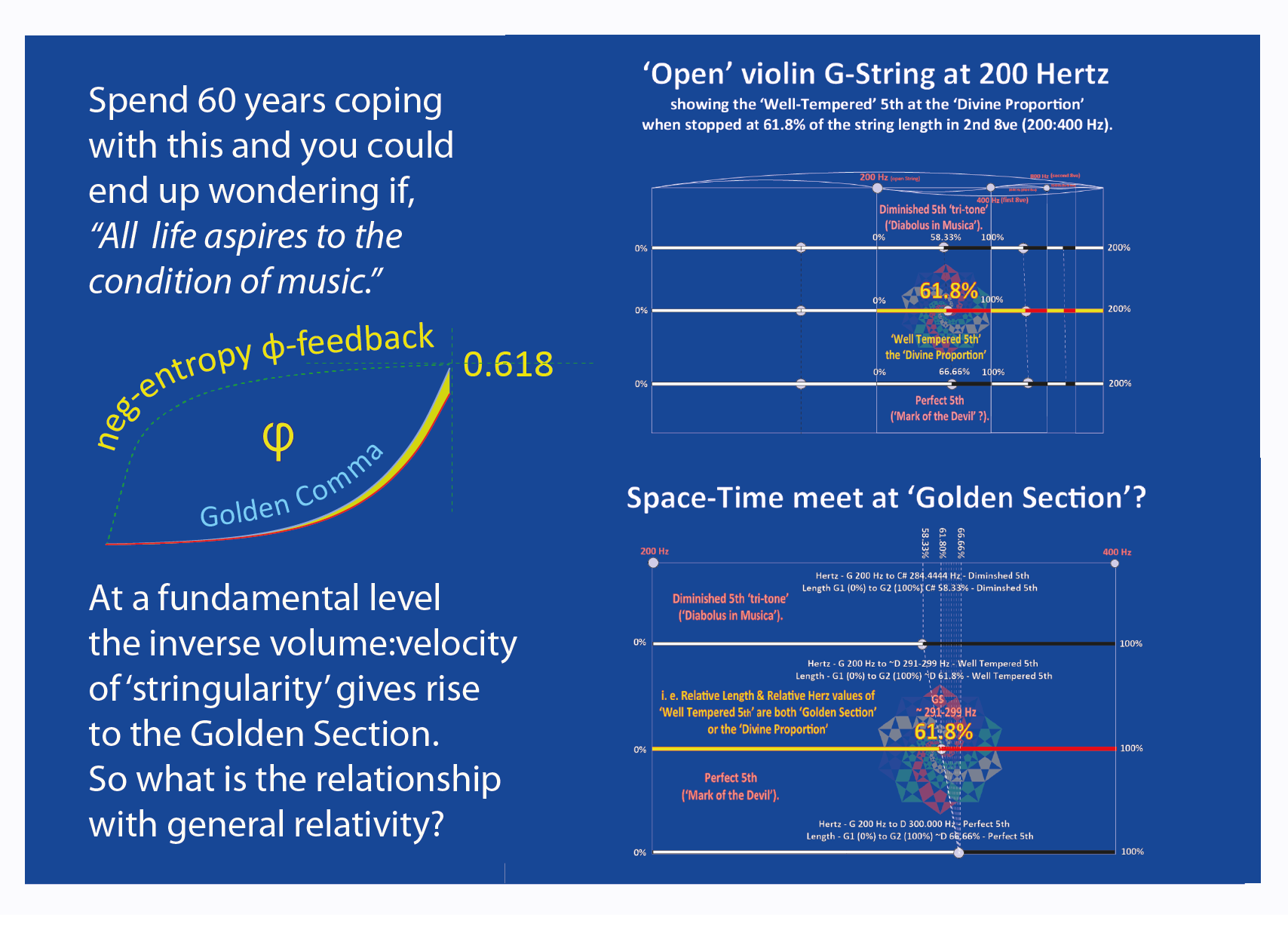
The Fibonacci sequence is a famous group of numbers beginning with 0 and 1 in which each number is the sum of the two before it. It begins 0, 1, 1, 2, 3, 5, 8, 13, 21 and continues infinitely. The pattern hides a powerful secret: If you divide each number in the sequence by its predecessor (except for 1 divided by 0), then as you move toward higher numbers, the result converges on the constant phi, or approximately 1.61803, otherwise known as the golden ratio.
My regenerative concept for the Trade Center was submitted to the New Visions New York panel for consideration as an overarching vision. The documentation is here. The concept of crystalline light shattering at 9:15 am on Sept. 11, in a site regenerated with a tree of life and "green towers" now lives on in many other urban design schemes.

 The selection of Portuguese architect Souto de Moura as this year’s recipient of the world’s highest recognition in the field of architectural design marks a change in direction of the juried selection from an apparent pattern of so-called ‘starchitect’ selections. Over the last few years, the laureates have been internationally recognized designers such as Zaha Hadid, Renzo Piano, Jean Nouvel, Frank Gehry and Peter Zumthor. Souto de Moura is best known for his design of the Paula Rego Museum (photo above) as well as participation in the Serpentine Pavilion of 2005 with Alvaro Siza. AR blogs about why his work was recognized this way.


